8.26. SPOT5
SPOT5 is a CNES (Space Agency of France) satellite launched on May 2002 and decommissioned in March 2015. SPOT5 contained two High Resolution Stereoscopic (HRS) instruments with a ground resolution of 5 meters. These two cameras were pointed forwards and backwards, allowing capture of a stereo image pair in a single pass of the satellite.
For the newer SPOT 6 and SPOT 7 satellites, which use a different format and camera model, see Section 8.27.
ASP supports only images from the HRS sensors on SPOT5. These images
come in two parts, the data file (extension .bil or .tif) and
the header file the data file (extension .dim). The data file can be
either a plain binary file with no header information or a GeoTIFF file.
The header file is a plain text XML file. When using SPOT5 images with
ASP tools, pass in the data file as the image file and the header file
as the camera model file.
All ASP tools can handle .bil images (and also .bip and .bsq)
as long as a similarly named .dim file exists that can be looked
up. The lookup succeeds if, for example, the .dim and .bil
files differ only by extension (lower or upper case), or, as below,
when an IMAGERY.BIL file has a corresponding METADATA file.
A sample SPOT5 image can be found at at http://www.geo-airbusds.com/en/23-sample-imagery.
8.26.1. Image preparation
SPOT5 datasets come in a directory structure where the front and back images
have the same name, without the path, and the same for the camera files. This
conflicts with the bundle_adjust assumptions.
A simple workaround is to rename the images and cameras:
mv front/SEGMT01/METADATA.BIL front/SEGMT01/METADATA_FRONT.BIL
mv back/SEGMT01/METADATA.BIL  back/SEGMT01/METADATA_BACK.BIL

mv front/SEGMT01/METADATA.DIM front/SEGMT01/METADATA_FRONT.DIM
mv back/SEGMT01/METADATA.DIM  back/SEGMT01/METADATA_BACK.DIM
8.26.1.1. Stereo with raw images
Run bundle adjustment (Section 16.5):
bundle_adjust -t spot5             \
  front/SEGMT01/IMAGERY_FRONT.BIL  \
  back/SEGMT01/IMAGERY_BACK.BIL    \
  front/SEGMT01/METADATA_FRONT.DIM \
  back/SEGMT01/METADATA_BACK.DIM   \
  -o ba_run/out
It is not clear if SPOT5 images benefit from bundle adjustment.
Run parallel_stereo (Section 16.51) with the adjusted cameras:
parallel_stereo -t spot5            \
  --bundle-adjust-prefix ba_run/out \
  --stereo-algorithm asp_mgm        \
  front/SEGMT01/IMAGERY_FRONT.BIL   \
  back/SEGMT01/IMAGERY_BACK.BIL     \
  front/SEGMT01/METADATA_FRONT.DIM  \
  back/SEGMT01/METADATA_BACK.DIM    \
  st_run/out
Here uses the asp_mgm algorithm. See Section 6 for a discussion
about various speed-vs-quality choices of the stereo algorithms.
This is followed by DEM creation with point2dem (Section 16.56):
point2dem st_run/out-PC.tif
8.26.1.2. Stereo with mapprojected images
For terrains with steep slopes, it is strongly suggested to run stereo with
mapprojected images (Section 6.1.7). For that, first use the
add_spot_rpc tool to generate an RPC model approximation of the SPOT5 sensor
model.
add_spot_rpc front/SEGMT01/METADATA_FRONT.DIM \
  -o front/SEGMT01/METADATA_FRONT.DIM
add_spot_rpc back/SEGMT01/METADATA.DIM        \
  -o back/SEGMT01/METADATA_BACK.DIM
This will append the RPC model to the existing file. If the output is a separate file, only the RPC model will be saved to the new file.
Then use the spot5maprpc session type when running parallel_stereo on the
mapprojected images.
Ensure that any external DEM is adjusted, if needed, to be relative the ellipsoid (Section 6.1.7.2).
See the note in Section 6.1.7.3 about perhaps reducing the resolution of the DEM to mapproject onto (and perhaps blurring it) if ghosting artifacts are seen in the produced DEM.
The mapprojection step is next (Section 16.41):
mapproject -t rpc                   \
  --bundle-adjust-prefix ba_run/out \
  --tr gridSize                     \
  sample_dem.tif                    \
  front/SEGMT01/IMAGERY_FRONT.BIL   \
  front/SEGMT01/METADATA_FRONT.DIM  \
  front_map_proj.tif
mapproject -t rpc                   \
  --bundle-adjust-prefix ba_run/out \
  --ref-map front_map_proj.tif      \
  sample_dem.tif                    \
  back/SEGMT01/IMAGERY_BACK.BIL     \
  back/SEGMT01/METADATA_BACK.DIM    \
  back_map_proj.tif
The grid size is the known ground sample distance (GSD) of the image, in meters. If not set, it will be auto-guessed.
Notice how we used the option --ref-map to ensure the second mapprojected
image uses the same grid size and projection as the first one. In older versions
of ASP, one must specify for both images the same projection in meters (such as
UTM), via --t_srs, and the same grid size, via --tr.
Stereo:
parallel_stereo -t spot5maprpc      \
  --bundle-adjust-prefix ba_run/out \
  --stereo-algorithm asp_mgm        \
  front_map_proj.tif                \
  back_map_proj.tif                 \
  front/SEGMT01/METADATA_FRONT.DIM  \
  back/SEGMT01/METADATA_BACK.DIM    \
  st_run_map/out                    \
  sample_dem.tif
DEM creation:
point2dem st_run_map/out-PC.tif
See Section 6 for a discussion about various speed-vs-quality choices of the stereo algorithms.
If desired not to use bundle adjustment, then need not set the option --bundle-adjust-prefix.
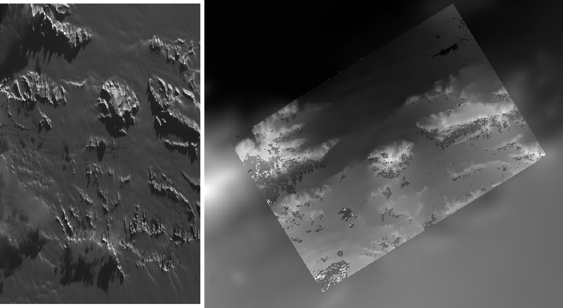
Fig. 8.53 Cropped region of SPOT5 image and a portion of the associated stereo DEM overlaid on a low resolution Bedmap2 DEM.