8.16. KPLO ShadowCam
ShadowCam is an instrument on the Korea Pathfinder Lunar Orbiter (KPLO). It is a high-sensitivity push-broom imager, about 200 times more sensitive than the Lunar Reconnaissance Orbiter Narrow Angle Camera (LRO NAC, Section 8.7). It was designed to image the floors of permanently shadowed regions (PSRs) using only secondary illumination, such as earthshine or reflection from sunlit crater walls. As a consequence, sunlit terrain typically saturates in ShadowCam images.
A more complete description is given in [HBBC+23].
This example is reproducible with ASP 3.7.0 (June 2026), which ships
custom-built conda packages of ISIS, ALE, USGSCSM, and SpiceQL that carry
the KPLO ShadowCam support that the official ISIS release (as of June 2026)
does not yet provide. See the install notes in Section 2.2. With the
official ISIS release this example cannot yet be reproduced.
8.16.1. Data and software
8.16.1.1. PDS observations
The mission archive is at https://pds.shadowcam.im-ldi.com. Each observation ships:
<id>SC.cub– full calibrated cube (about 1 GB)
<id>SE.cub– the shadowed extract, a calibrated cube cropped to the portion of the strip that contains useful signal (about 255 MB)
<id>S_map_raw.tif– mapprojected raw cube
<id>S_map_stretched.tif– mapprojected cube with a visual stretch (for display only, not for measurement)PDS4 XML labels for each product.
The SC.cub and SE.cub files are radiometrically calibrated and can be
used directly as ASP inputs. The archive is organized by acquisition date,
with each observation in its own subdirectory.
The example below uses the south-polar pair acquired on 2024-12-11
(day 346): M074289249SE and M074296291SE. The calibrated
shadowed-extract cubes, their PDS4 labels, and the map-projected stretched
orthoimages can be fetched with:
base=https://pds.shadowcam.im-ldi.com/observation/2024/346

curl -fsSL -O $base/M074289249S/M074289249SE.cub
curl -fsSL -O $base/M074289249S/M074289249SE.xml
curl -fsSL -O $base/M074289249S/M074289249S_map_stretched.tif

curl -fsSL -O $base/M074296291S/M074296291SE.cub
curl -fsSL -O $base/M074296291S/M074296291SE.xml
curl -fsSL -O $base/M074296291S/M074296291S_map_stretched.tif
8.16.1.2. SPICE kernels
The KPLO kernels are not yet hosted in the ISIS data area.
They can be fetched via the rsync modules at the ShadowCam Science
Operations Center (rsync.im-ldi.com::kplo).
The kplo/kernels/ tree below mirrors the layout other missions use under
$ISISDATA. Only the kernel files spanning the acquisition date of interest
are needed; a single day of reconstructed attitude and trajectory data is
typically only a few tens of MB.
Fetch the minimal set of kernels for the 2024-12-11 pair into the local ISIS data area:
mkdir -p $ISISDATA/kplo/kernels/{ck,spk,sclk,fk,ik,iak,pck,tspk}
rsync rsync.im-ldi.com::kplo/kernels/ck/    \
  --include='kplo_sc_20241211_*' --exclude='*' \
  -P $ISISDATA/kplo/kernels/ck/
rsync rsync.im-ldi.com::kplo/kernels/spk/   \
  --include='kplo_d_20241209_20241212_*' --exclude='*' \
  -P $ISISDATA/kplo/kernels/spk/
rsync rsync.im-ldi.com::kplo/kernels/sclk/  \
  -P $ISISDATA/kplo/kernels/sclk/
rsync rsync.im-ldi.com::kplo/kernels/fk/    \
  -P $ISISDATA/kplo/kernels/fk/
rsync rsync.im-ldi.com::kplo/kernels/ik/    \
  -P $ISISDATA/kplo/kernels/ik/
rsync rsync.im-ldi.com::kplo/kernels/iak/   \
  -P $ISISDATA/kplo/kernels/iak/
rsync rsync.im-ldi.com::kplo/kernels/pck/   \
  -P $ISISDATA/kplo/kernels/pck/
rsync rsync.im-ldi.com::kplo/kernels/tspk/  \
  -P $ISISDATA/kplo/kernels/tspk/
The full ck tree is several GB and grows daily; pull only the date range
of interest.
The lunar planetary constants and base body ephemeris are shared with other
ISIS lunar missions; ensure the standard base/kernels/ files (such as
de430.bsp) are present under $ISISDATA.
8.16.2. Preprocessing
Attach the SPICE kernels to a calibrated cube:
spiceinit from = M074289249SE.cub
Create a CSM (Section 8.12) camera with isd_generate from the ALE package.
As with HRSC (Section 8.10.3), this requires the ASP custom build of ALE
(and ISIS), which is already included in the ASP 3.7.0 conda environment
(Section 2.2); the official ISIS release (as of June 2026) does not
yet support ShadowCam.
The -k flag tells isd_generate which cube’s attached SPICE kernels to
use; here the cube supplies its own, set earlier by spiceinit:
isd_generate -k M074289249SE.cub M074289249SE.cub
This produces M074289249SE.json. Repeat for the second observation.
Validate the CSM camera against the ISIS camera with cam_test
(Section 16.9):
cam_test                    \
  --image M074289249SE.cub  \
  --cam1  M074289249SE.cub  \
  --cam2  M074289249SE.json \
  --session1 isis           \
  --session2 csm            \
  --sample-rate 50
The cube-to-CSM agreement should be on the order of 0.01 pixels.
8.16.3. Sanity check against the PDS ortho
A quick way to verify the kernels and the CSM model is to compare a locally mapprojected version of the cube against the PDS-shipped mapprojected orthoimage. Set up a south-polar stereographic projection:
proj="+proj=stere +lat_0=-90 +lon_0=0 +k=1 +x_0=0 +y_0=0 +R=1737400 +units=m +no_defs"
Mapproject at a deliberately very coarse resolution (Section 16.41):
mapproject          \
  --tr 50           \
  --t_srs "$proj"   \
  ref.tif           \
  M074289249SE.cub  \
  M074289249SE.json \
  M074289249SE.csm50.tif
Warp the PDS product to the same grid (each PDS map is in its own oblique stereo frame, so a reprojection is required):
gdalwarp -t_srs "$proj" -tr 50 50 -r bilinear \
   M074289249S_map_stretched.tif M074289249SE.pds50.tif
The two GeoTIFF images should agree when overlaid in stereo_gui
(Section 16.71), up to a small horizontal shift and a radiometric
stretch.
The reference DEM ref.tif can be an existing LOLA gridded product
(Section 11.10.2), or one produced with point2dem from LOLA
RDR samples
(Section 16.56.2.7).
8.16.4. Bundle adjustment
Run bundle_adjust (Section 16.5) on the cubs and the CSM
JSONs, with a large interest-point budget so enough survive the matching
stage on the few well-textured (shadowed) parts of the strip:
bundle_adjust                         \
  --ip-per-image 50000                \
  M074289249SE.cub  M074296291SE.cub  \
  M074289249SE.json M074296291SE.json \
  -o ba/run
If interest point matching fails, or if a specific region is of interest, consider mapprojecting the left and right images onto a DEM clip with a local projection and the same ground sample distance (GSD) for both (Section 6.1.7.6). The nominal GSD for ShadowCam is 1.7 m/pixel.
Then add these mapprojected images to the bundle_adjust command
(Section 16.71.13):
--mapprojected-data 'M074289249SE.map.tif M074296291SE.map.tif'
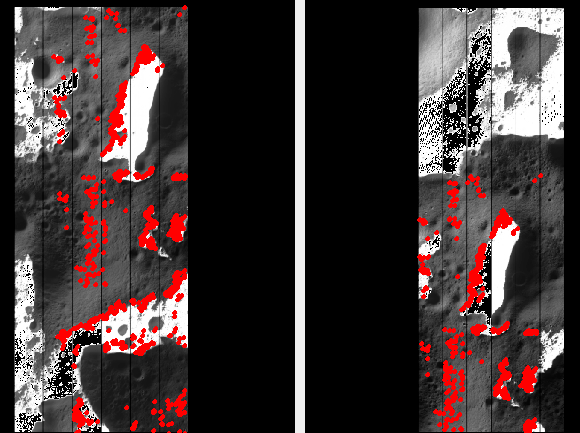
Fig. 8.31 Portions of the left and right ShadowCam images
M074289249SE.cub and M074296291SE.cub, with interest point
matches overlaid in red. ShadowCam images tend to be saturated in
well-lit areas and show texture only in shadowed pixels.
8.16.5. Stereo
The reported stereo convergence angle (Section 16.5.11.4) for this pair is approximately 24 degrees, which is well-suited to stereo.
A quick preview run can be done with stereo_gui (Section 16.71) as:
stereo_gui                                \
  --stereo-algorithm asp_mgm              \
  --subpixel-mode 9                       \
  --alignment-method local_epipolar       \
  M074289249SE.cub                        \
  M074296291SE.cub                        \
  ba/run-M074289249SE.adjusted_state.json \
  ba/run-M074296291SE.adjusted_state.json \
  stereo_nomap/run
Two clips can be selected with Control-Mouse drag and processed via the
parallel_stereo entry in the menu. The full images can be processed
directly with parallel_stereo from the command line.
This uses the bundle-adjusted CSM state files (Section 8.12.6) produced earlier.
Set the same south-polar stereographic projection as before:
proj="+proj=stere +lat_0=-90 +lon_0=0 +k=1 +x_0=0 +y_0=0 +R=1737400 +units=m +no_defs"
Produce a DEM (Section 16.56) at a grid size coarser than the image GSD. Here we use 5 m, which is about 3x the 1.7 m image GSD (Section 16.56.4):
point2dem --tr 5         \
  --t_srs "$proj"        \
  --errorimage           \
  --orthoimage           \
  stereo_nomap/run-L.tif \
  stereo_nomap/run-PC.tif
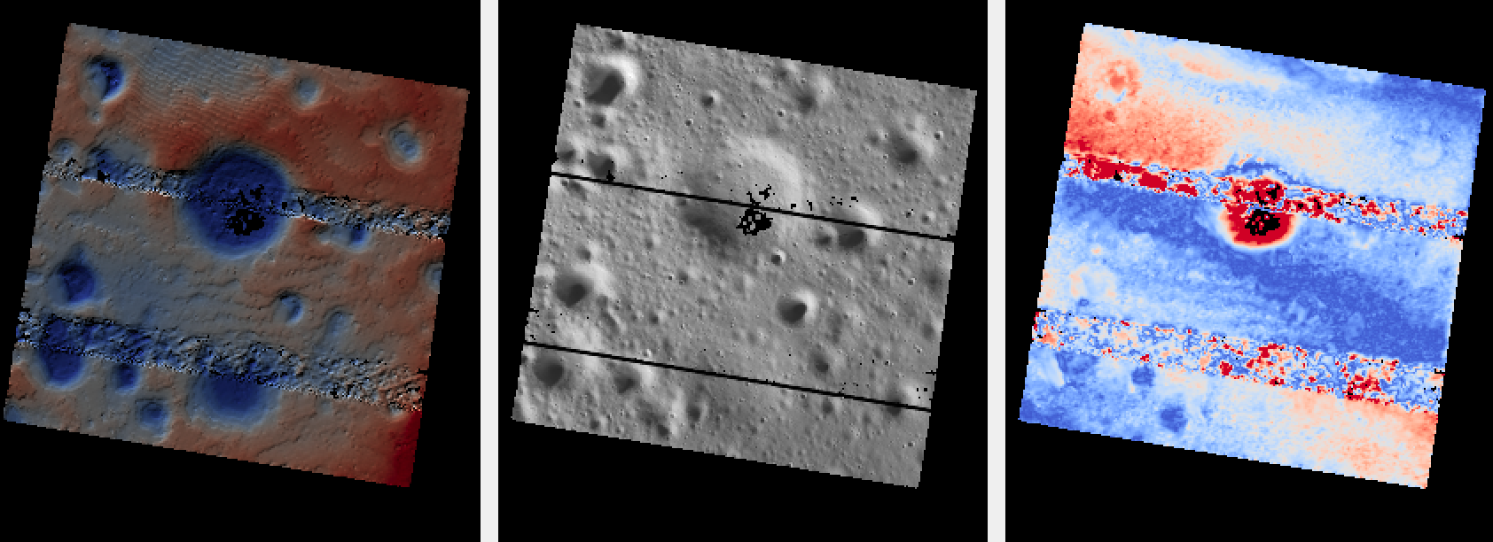
Fig. 8.32 A small DEM clip (left), the corresponding orthoimage (middle), and the
triangulation error image (right) produced by point2dem. Seam artifacts
are visible across all three panels and are likely an effect of input data
processing.
For datasets with steep terrain it is suggested to run parallel_stereo on
mapprojected images (Section 6.1.7). The reference DEM for
mapprojection can be the one just produced, or a prior LOLA-derived product that
is well-registered to this data. In either case, some hole-filling and blurring
of the DEM before use are recommended (Section 16.20.2.9).
Mapproject onto a DEM called ref.tif, at the native ShadowCam ground sample
distance of 1.7 m:
for f in M074289249SE M074296291SE; do
  mapproject --tr 1.7               \
    --t_srs "$proj"                 \
    ref.tif                         \
    ${f}.cub                        \
    ba/run-${f}.adjusted_state.json \
    ${f}.ba.map.tif
done
Stereo with mapprojected images:
parallel_stereo                           \
  --alignment-method none                 \
  --stereo-algorithm asp_mgm              \
  --subpixel-mode 9                       \
  M074289249SE.ba.map.tif                 \
  M074296291SE.ba.map.tif                 \
  ba/run-M074289249SE.adjusted_state.json \
  ba/run-M074296291SE.adjusted_state.json \
  stereo_map/run                          \
  ref.tif
Note the last argument is the reference DEM used at the mapproject stage.
A DEM can be made as before.
8.16.6. Alignment to LOLA
The produced DEM can be aligned to LOLA with pc_align (Section 16.53),
following the same procedure as Section 8.7.7.
LOLA returns measurements in permanently-shadowed areas, which is especially valuable for ShadowCam.